I want to stop the old woman in Abu Deleig from mixing two heaping spoonfuls of dehydrated milk and almost an equal amount of sugar into my morning cup of tea, but when I sip what she’s done, I find it’s delicious and consume it like fuel. She smiles and brings biscuits for dunking.
Last night when I tried to stop eating from the communal tray because it was so late the generator had been turned off, Omima told me, “In Sudan, there are three things you don’t stop. If you find food, don’t stop. If you find love, don’t stop. If you find sleep, don’t stop. Because once you stop these things, you might not find them again!”
Omima is a young veterinarian and International Fund for Agricultural Development (IFAD) employee assigned to Abu Deleig. She has taken it upon herself to look after me, and for this, I am grateful. Among the women working in Abu Deleig, her English is strongest.
“Change your clothes,” she tells me as we finish our tea. “Because you are from outside, the village women will focus on you.” She tells me I must pay more attention to washing and ironing.
I don’t like wearing these clothes, any of them, because it is too hot.
With one hand, Omima gathers the edge of my skirt. “This skirt is dusty,” she says. “It is not OK.”
There is dust everywhere in Sudan. A whole country of dust.
A week ago, Omima led me by the hand through the dense crowds of Sudan’s largest souk—the Omdurman market—to purchase this skirt. I know in the villages a skirt is more appropriate than pants.
“Wear your pants,” Omima tells me as we prepare to set out on our fieldwork, “and we will wash the skirt tonight.”
It is so arid in this part of Sudan that wet laundry hanging on the line will dry in ten minutes.
I dress in loose beige pants, a long-sleeve mauve blouse, and a matching headscarf.
“I think it is OK,” Omima says, contemplating my appearance, but when we step beyond the walled courtyard of the women’s house, a few of the older village women show their disapproval through downcast stares.
I think it’s more than my pants, but I remind myself that I am the outsider and that one person’s field site is another person’s home.
Between 1982 and 1984, a hydrogeologist by the name of W. Mike Edmunds—then working for the British Geological Survey—traveled to the Butana region of Sudan, a dryland east of the Nile River, to lead a collaborative study of the Lower Atbara River Basin. Mike’s investigation of wadi-directed recharge—that is, how and to what extent wadis, or ephemeral rivers, conduct rainy-season water to the shallow, alluvial aquifers underneath—highlighted the importance of this kind of recharge and became a key study in the world of dryland hydrology.1Although the study has been summarized and reprinted in a few forms (1992; 1995), the original study is Edmunds, W. M. et al. 1987. Estimation of aquifer recharge using geochemical techniques: final report of the Lower Atbara River Basin Project. Because Is there water? isn’t the only question. One must also immediately consider if it’s accessible. And if we drink it now, will there be more for later? As luck would have it, Mike’s 1982 field site included the remote 2,000-person market village of Abu Deleig.
Thirty years later, Mike Edmunds, now a professor at the University of Oxford and my mentor, handed me his field notes, photos, and maps of Sudan as we drank coffee in Blackwell’s Bookshop on Broad Street and discussed my own plans to journey to Abu Deleig.
“This is yours truly,” Mike said, pointing from across the table at a younger image of himself. The brown-bearded man in the photo wears an expedition hat, hiking boots, a collared shirt, and short shorts I wouldn’t be allowed to wear. He stands, with arms crossed, on a wooden platform overlooking Abu Deleig’s main wadi, which, for all but a few days of the year, is dry. In the background, a single acacia tree and a village market scene of produce and spices, diesel trucks, and barefoot boys herding goats.
In all of the photos Mike took of Abu Deleig, sand and rock dominate pale blue sky. The photographer is a man with his eyes to the ground. As we flipped through the old photographs, Mike lamented that he and the other hydrogeologists had not engaged with residents of Abu Deleig or nearby villages. Their study was purely technical.
“Nowadays, we think more broadly; we consider sustainability,” Mike said. “Thirty years ago, we conducted our studies more narrowly.”
I promised my professor I would think more holistically about water storage, consumption, and recharge. It was important to me to speak with people and consider the ways they had adapted to life in dry conditions. Even so, I considered my study quantitative, and looking back, I think it was precious how little I realized everything I might accomplish—scientific or otherwise—would depend on the kindness and good graces of other people.
I carried Mike’s carefully folded maps with me to Sudan and to Abu Deleig. On one of these maps, the locations of wells he sampled were penciled in along the wadi within an area triangulated by tombs. I also took a small pile of photographs from 1982 to show residents of the village, because even though the village had grown more than tenfold since my professor’s visit, people recognized landmarks—especially the tombs—and some of the older individuals remembered particular wells. One or two people even remembered Mike.
My field site was smaller but overlapped the area Mike had studied. Mine was a 378-square-kilometer area that included a twenty-kilometer stretch of Wadi Jugjugi—Abu Deleig’s main ephemeral river—which flows seasonally into Wadi el Hawad, which in turn contributes to the Atbara River. But the real contribution of these ephemeral rivers is not in surface flow to the Atbara or Nile Rivers; the contribution comes in the form of groundwater recharge to the shallow aquifers underlying Abu Deleig and the remote, sand-swept villages beyond Abu Deleig.
Throughout the summer of 2012, I made several trips from Khartoum to Abu Deleig and surrounding villages in order to collect water samples and to speak to village residents about their water use. I would find Mike’s wells on the map, and I resampled as many of them as possible. At that time, I did not know that wells—which once were scarce—now populate the sides of Wadi Jugjugi in parallel strings. Some of the wells are only twenty meters apart.
That year—2012—was the first year of South Sudan’s independence, and the Republic of Sudan was in many ways struggling to re-establish its national identity and reassess its natural resource wealth. Before Sudan split into two countries on July 9th, 2011, it was the largest country in Africa. It contained, by some accounts, more than five hundred ethnic groups; the region has a complicated and multitudinous history. Yet, the familiar history of Sudan, at least in much of the news from the West, continues to be written as the narrative of a now-free South Sudan and is oversimplified into a discussion of the Muslim North versus the Christian South. This narrative does a disservice to our ability to understand the anti-Bashir dialogues in the North and the tribal conflicts now erupting across South Sudan.
Although Abu Deleig was only a four-hour journey from Khartoum via an unmarked sand road, it was culturally a world away. The political instability of Khartoum did not seem to register in Abu Deleig; in the same way, the threat of environmental devastation was not ever-present in Khartoum.
In the capital, “austerity riots,” as they were named by the press, were taking place that summer as underrepresented minorities protested the Bashir regime, men argued with bus drivers over the hikes in gas prices, and students from the region’s most prestigious university marched in the streets.
One of these protests erupted while I was quietly reading in a back room of the Sudan National Library. Suddenly, students began running into the library for shelter. They were yelling, coughing, and, in some cases, crying. The library keeper admitted the students and quickly boarded the doors against the renewed onslaught of tear gas.
Another time, I watched the beginnings of an “austerity riot” from an office inside the Department of Civil Engineering at the University of Khartoum. I heard clapping, raised voices, and the occasional exaltation of “Allahu Akbar!” and exited the office to watch the students gathering in the courtyard. The group was mostly male, and one of the boys, as he marched past, shot me a smile and said in English, “Hello. How are you? Good?” More smiles. A few giggles escaped from covered mouths. These students were young and bright—Sudan’s crème de la crème. Riot didn’t seem the proper term.
The students would march beyond the university borders, some up the street to the Sudan National Library and the Ministry of Agriculture, and others, exiting by the side entrance, toward the Ministry of Health. Once they left the safety of the university, they were met with tear gas and police force. They were sprayed, pummeled, detained, and dealt with. They risked their academic futures, their careers, and, in some cases, their lives.
I spent the first anniversary of the Sudan/South Sudan split performing water analysis in Khartoum. When I went to the university cafeteria for lunch, things seemed eerily muted. There were no demonstrations; the television played only soap operas and shampoo commercials. Initially, I was disappointed the day didn’t seem more obviously marked until I realized that what I should be listening for was the evolution and history of the North. With the secession of South Sudan, a new North Sudan was birthed as well. Its story is told through its proud cities and agricultural schemes as well as through its long conflicts and its dusty desert towns like Abu Deleig.
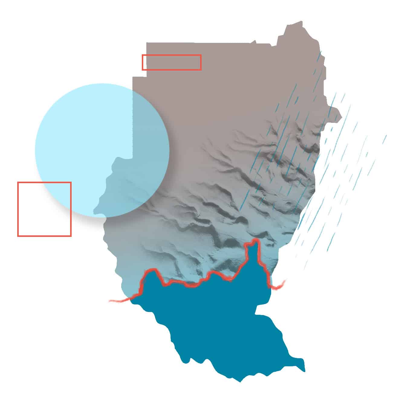
Perhaps the most significant difference between North and South Sudan is the climate—South Sudan receives more rain. This increase in rain (as well as a different kind of soil) in South Sudan contributes to a different form of agriculture and cattle raising that revolve around flooding. A precipitation map of Sudan shows a rainfall gradient from zero to twenty-five millimeters per year along its northern, hyper-arid border with Egypt to as much as one thousand millimeters per year in the mountains and far southern fringe, where it borders South Sudan. However, when we compare precipitation and aquifer maps of Sudan, we see that the largest groundwater reserves are in areas of low rainfall, and this suggests these groundwater reserves formed under past climatic conditions and are nonrenewable. Nonrenewable groundwater is defined as that which would require hundreds and thousands of years to recharge. So, along with more than half of the oil reserves, the South Sudan secession took the majority of renewable groundwater.
Certainly all cities in arid and semi-arid regions—cities like Khartoum, Cairo, Tel Aviv, Sydney, Phoenix, and L.A.—are constrained by water; water stress is what they share. Yet many of the world’s largest cities are buffered by surface water. They also have access to rivers, reservoirs, pipeline transfers, or coastal desalination.
In Khartoum, of course, there is the Nile River. Sudan’s water politics focus routinely on the Nile, yet more than 80 percent of Sudan is dependent on groundwater for most of the year. Even cities like Omdurman, Khartoum, and Khartoum North, with their positions along the banks of the Nile River, derive 70 percent of their water from the Nubian Sandstone Aquifer underneath greater Khartoum.
Renewable groundwater has been called the key to water security in dry regions. One might say Sudan’s groundwater is a precious resource that, in many ways, is more valuable than gold and should be managed with as much care as its petrol and mineral wealth.
But in rural, isolated towns like Abu Deleig, water stress is more acute, more immediately felt. People worry about whether or not it will rain.
On the outskirts of Abu Deleig, there is only dust, rock, and sun, as far as the eye can see. Some might be inclined in such a landscape to gaze toward the sky, but the earth is hard and expansive, and what lies underneath is refuge from the sun.
Abu Deleig, and the Butana region more generally, is a parched land controlled by rain, wadis, and groundwater. The earth is sandstone or crystalline basement, and the nearest whispers of water come from the shallow alluvial deposits found along the wadis. Geology dictates where humans can settle because access to groundwater is dependent on rocks. Except for the smallest of pockets, groundwater is not accessible from the harder basement complex. For this reason, most of the villages have developed along the wadis. Abu Deleig and many of the rural villages in my study area have developed along Wadi Jugjugi because its focused, seasonal flow of water recharges the shallow alluvial aquifer underneath. When it rains, the river runs, and then the water table rises.
Rain shapes the people and culture of the Butana. The rain begins in June, is more pronounced in July, and is heaviest in August. Nearly all the annual rainfall arrives during this period.
Before the rains arrive, the landscape is brittle-looking and barren, and vegetation is sparse. The dominant tree—Acacia tortilis in Latin or seyal in Arabic—is brown and barely visible on the landscape. Many of the shallow wells run dry, and villagers on the outskirts of Abu Deleig are forced to travel greater distances for water. Goats, sheep, and donkeys must be watered. Sometimes this is done by allowing them to drink rainwater collected in small, earthen catchments called haffirs, but by June, nearly all the haffirs in the Butana are dry. Humans will sacrifice some of their water to water their livestock for as long as they can. In the absence of rain, dust storms are especially fierce. Habub is the Sudanese name given to these dust storm events, which can be strong enough to blind a person and rip rooftops from houses.
Finally, when the rain arrives, it impregnates the earth, and within days of even a minor soaking, thousands of grass shoots rise through the sand. Eventually, the acacia trees produce leaves that are a brilliant green, and the landscape explodes with color.
Flashy is often used to describe the intensity of dryland rain events. The first substantial rain of the season may cause flooding along wadis and floodplains. Every few years, there are reports of a home, of livestock, or even of a person being swept away in the brief flood event. The name of Abu Deleig’s main wadi, Jugjugi, comes from the terrible sound that rushing water makes before it sweeps someone away.
Despite the intensity of these individual rain events, rain in the Butana is infrequent. A rainy season could, for example, bring only four isolated rain events. According to my own data, the mean annual precipitation in Abu Deleig for the years 1905–1985 is 203 mm/year. But, as may be expected, interannual variability is high, and during droughts, the annual rainfall is radically less than the mean. During the drought years of 1983 and 1984, there was a combined rainfall of only fifteen mm. Every resident of Abu Deleig alive during that time remembers the drought. Livestock died, and the town began to think it had reached its limits for growth.
There is not enough rain to sustain crops without irrigation in the Butana, and most families don’t have enough water even for household plants. Rural development projects have increased access to groundwater. They have built small dams and reservoirs to collect rainwater, and introduced family gardens. In villages where boreholes have allowed for increased consumption of water, some families will grow an apricot tree.
I came to this dryland region of Sudan, as my advisor had done thirty years before me, to examine how well this shallow alluvial groundwater system—on which all the people of Abu Deleig and the surrounding villages depend—sustains itself. It may seem counterintuitive, but drylands are a wonderful place to study water. I find that in areas where water is scarce, water is understood to be precious. Very little water is wasted, the act of drinking is relished, and each rain event is something to celebrate.
Of course, when Mike traveled to Abu Deleig in 1982, the town had a population of two thousand people. In 2012, there were over ten times as many people, and most of the old hand-dug rope-and-pulley wells, some of which had been in use for more than a century, had been replaced by boreholes with diesel-engine pumps.
My research question: is this groundwater extraction sustainable?
Astonishingly, it is still possible to walk across the desert by following the rain and by knowing where in the endless sand-swept landscape the people walking before have built haffirs. I learn this from Asha, a stooped sixty-year-old woman with grooved skin, who, when she speaks, grasps my forearm and pulls me nearer.
When the rains come, Asha tells me in Arabic, she and her family will start walking south with their livestock. They’ve done this before—for as long as memory permits—and Asha shares her memories of moving from one haffir to the next. She talks about the taste and feel of the different kinds of water. For emphasis, Asha releases my forearm; she motions up toward the sky and points down to the soil. Then she pinches her fingers together and rubs them slowly. She says the first rain will taste more strongly of earth.
Asha is a member of the Ja’alin tribe, whose nomadic cycles coincide with the rainy season. The Butana has always been home to nomads. In dry areas, resources like vegetation and water are ephemeral, appearing only briefly on the landscape. Several tribes in Sudan—including Asha’s—still practice seasonal migration. However, as livestock populations have increased, so have conflicts over migratory grazing and watering.
Nomads have herded their livestock across the Butana since its greener, grassier days. Now, when the Butana is one of the dryer regions of Sudan, there are benefits to raising livestock. They can be herded to available resources.
Livestock remains the dominant livelihood and measure of wealth in the Butana. This emphasis on livestock is practical as well as cultural. Even poor families in the villages of my study area have a goat or two for milk and perhaps a donkey for water transport. Wealthier families have more goats and sheep for milk, wool, and meat, and the wealthiest families in Abu Deleig may have hundreds of camels.
Back at the women’s house in Abu Deleig, where I am staying, Omima and several of the other female Sudanese development workers reveal that they find my preoccupation with Asha amusing. It is not unusual for people who’ve grown up in a city to disregard the value stored in the memories of those still walking the Butana.
“Hawama!” Omima yells, using the derogatory word for “nomad,” and several of the women from Khartoum slap their sides and shriek with laughter.
“Are you a hawama?” they ask me.
I imagine walking across the desert, having the skill to do so.
“I want to be,” I say. And I mean it.
Beginning in the early 1900s and for half a century thereafter, the northern deserts of Sudan appeared in the descriptive exploratory accounts of a series of bold British expeditions that moved through the deserts of Libya, Egypt, and Sudan. Among these imperial British accounts—which noted movements of nomads, species of acacia, and the “advance of the creeping desert”—were reports from Shaw, Stebbing, Bagnold, and Corbyn, who, for a time, also served as a governor of Khartoum. Corbyn’s brief 1945 report on soil conservation in Anglo-Egyptian Sudan expresses concern over erosion, de-vegetation, and the deterioration of rural water supplies, much of which was blamed on the overgrazing of livestock. Stebbing’s 1953 book, Creeping Desert in the Sudan and Elsewhere in Africa, includes a preface from Abdulla Khalil, the former minister of agriculture, who would, in 1956, become the second prime minister of an independent Sudan. It reads: “[T]he welfare of our country depends on the conservation, as well as the exploitation, of our natural resources.”
Sudan has long been the epicenter of the desertification debate. The phrase advance of the creeping desert was birthed in Sudan and can be understood, very simply, to mean what happens in drylands when vegetation is removed and rain is withheld. Debates about the causes of desertification usually focus on either natural (climatic) or human-induced (farming and grazing) pressures. At one time, this advancing desert line was thought to be a “sand sea” whose waves consumed grassland, farmland, and entire villages. In 1975, Hugh Lamprey, a British ecologist and bush pilot, famously asserted that between the years 1958 and 1975, the Sahara Desert had advanced a hundred kilometers southward across Sudan.2Lamprey’s assertions were contested and found to be based on insufficient evidence. See Tucker et al. 1991, Hellden 1991, and Thomas and Middleton 2004. Abu Deleig lies just north of Lamprey’s original line of creeping desert.
Today, we believe that land degradation (a term that does not carry the political charge of desertification) is caused by multiple factors, including prolonged drought, and that deserts are dynamic environments where vegetation blooms and dies according to brief rain events.
Historically, in arid landscapes, surface waters have been used to cope with harsh conditions. Humans have also utilized proximity to fault lines and access to groundwater—as through qanats (a series of shafts and tunnels for moving water) and hand-dug wells—to mitigate arid environments. However, current, more efficient methods of withdrawal and higher rates of extraction now pose looming problems for human populations and megacities dependent on nonrenewable groundwater.
The term sustainable development was first explicitly defined in 1987, in Our Common Future (also known as the Brundtland Report, the result of an international summit devoted to sustainable development), as “development that meets the needs of the present without compromising the ability of future generations to meet their own needs.” Many definitions have been offered since, most incorporating a “do no harm” philosophy applied to the long term. Sustainable groundwater management is sometimes interpreted to mean “withdrawal that does not exceed recharge.” However, if we determine water balance only with respect to quantity, we fail to address something almost as important: the water’s quality.
Sustainable groundwater use prioritizes safeguards against aquifer pollution and uses metrics that consider water quantity and quality.
Careful management of aquifer systems can be an important buffer against land degradation. Widespread monitoring of groundwater resources, from changes in aquifer storage to specific water-point abstraction estimates, would be a substantial improvement. In rural areas, methods of monitoring abstraction range from measuring the length of rope used to haul buckets out of wells to near real-time monitoring using mobile phone networks.3For an example of how cell phone technology can be used to monitor handpumps in rural areas see Thomson, P. et al. 2012. Managing groundwater through the lens of an integrated watershed may help encourage aquifer recharge. In areas where annual rainfall is low or where rainfall variability is very high, recharge from rivers and wadis becomes crucial.
Abu Deleig provides an interesting test case for sustainable desert living because, for as little as the people of Abu Deleig consume, their water abstraction—that is, the amount of the groundwater they remove—has greatly increased in the past three decades, along with the town’s population. Most of the wells are located along the Wadi Jugjugi. To further complicate matters, this watershed is completely ungauged, and abstraction is unmonitored. This represents the hydrological reality facing many arid regions around the world.
Asha is visually stunning. A thin line of what looks like kohl outlines her hard hazel eyes, which are, just at the periphery, a pale blue. Her lips are also outlined—I’m told by tattooing—and the mauve tone adds fullness to her lips but also blends into her olive skin. Asha’s eyebrows are barely visible, her nose is flat, and knife marks have left two parallel gorges on either cheek. These marks, deep and dignified, run from the hollowed areas around Asha’s eyes, down her wrinkled cheeks. Asha’s hair is braided, and two of the braids fall from beneath the wrap of her headscarf.
The women in the rural areas do not have photos of themselves, so when I show them their images on my camera’s playback screen, they huddle over the camera, smile, and nod approvingly. Some of the women hold their mouths and laugh when they recognize themselves or a neighbor. The images become even more precious if they include a child.
In one of these photos—one of my favorites—Asha stands in the forefront of the photo; to her side, a mother, a young girl, and a newborn represent four generations of tribal lineage. Asha stares into the camera with a captivating gaze.
My purpose for visiting is not to take photos; my purpose is to survey the villagers about their water consumption and to interview the elders about their management of water resources. But each time I visit Asha’s village, or any village, people invite me into their homes and they offer me food and water. So I respond by bringing bags of tea and sugar. I learn that if I take photos during my visit, I can return and give printed copies to express my gratitude.
I always drink the water I was offered. I come to know each village by where it sits along the wadi catchment and whether it derives water from a hand-dug well with rope and bucket or from a newer borehole with a submersible pump. I know the depth of the wells and how salty the water. I do chemical and biological testing of each water source, and sometimes I sample from household or schoolyard water storage barrels.
I cannot, in good conscience, listen to a family’s hardships—how the woman’s son had died and the granddaughters had stopped attending school to assist with chores, including a four-hour roundtrip journey each day for water—and not drink the cup of water offered to me on a tray. I accept the water graciously and thank my hosts. I drink even if the water tastes salty.
Salt can be an indication of water scarcity. Conversely, salt can indicate too much water. Salt through excess typically appears when too much water is used to irrigate dryland crops or when the water table is very high. Drylands, by definition, experience high rates of evapotranspiration, meaning that open pools of water and soil moisture found near the surface evaporate or are transpired by plants, leaving behind deposits of salt. When it rains, this salt will dissolve and flow into shallow wells or open haffirs. This kind of salty water is unpleasant, but as the rains continue, or as the well deepens, the taste of the water improves. Sometimes, though, salty water results as a well is drained of all its available fresh water and the denser, saltier water is drawn. I imagine tasting this water would be more frightening—more final—than tasting water made salty through excess.
When I write salt, I mean minerals formed from sodium, magnesium, or calcium cations bound to chloride, sulphate, or carbonate anions. These trace elements reveal the history of specific water. In this way, water retains the memory of where it’s been. If we really tasted our water, it would tell us stories.
In my surveys, I ask the residents of Abu Deleig and surrounding villages to describe the taste of their water. I ask if residents have noticed a change seasonally or in the past few years. The residents of some villages report a salty taste; some say the water had become saltier as the number of wells has increased. One of the women in Asha’s village jokes that saltier water is good for cooking lentils.
I measure salt—or more precisely, chloride concentrations—to quantify how quickly water travels from the atmosphere into the ground and replenished the aquifer. This is known as the chloride mass balance approach to measuring the rate of recharge. Knowing the rate of recharge is important because those dependent on groundwater will not want to consume more water in the long term than what is replaced. To establish the rate of recharge, I have to know the chemical composition of rain.
Now I am like everyone else in Abu Deleig; I must wait for it to rain.
“The problem in Abu Deleig,” says Abdelbagi Hussein slowly, thoughtfully, “is a shallow aquifer affected by dryness.” For seven years prior to the secession of South Sudan, Abdelbagi represented the interests of Butana dryland residents on the legislative council in Khartoum. In the city, where he sometimes swaps his traditional dress for a suit, his movements must appear sluggish, a little out of step. In Abu Deleig, he is regarded as a village elder—a custodian of the people’s water.
When I ask Abdelbagi to explain what he means by dryness, he says, “Some years the rain will be very weak.” I press him for ways in which he observes this. He answers by speaking about the rainfall, the grass, and the water table.
On one of my first days in Abu Deleig, Abdelbagi shows me a series of wells running along the wadi and calls each one by name. He remembers, for the most part, the year they were dug or drilled and their initial productivities.
Abdelbagi tells me what others in Abu Deleig and surrounding villages will tell me: during these dry times, the productivity of wells drops. But Abdelbagi also understands something about the water that not everyone else does. He is concerned that there are too many wells, that some of the wells have been drilled too close together. He thinks the aquifer should be modeled in a way that accounts for all of the wells already in place.
I think he is right.
The first time I feel rain on my face in Sudan is on July 19th, 2012, in the courtyard of Abdelbagi’s family house. It is Abu Deleig’s third rain event of the season—the two previous rains had occurred on July 4th and July 8th. Because there is no electricity for fans and because the summer heat begs a breeze, most Sudanese sleep outside. Half a dozen female family members are sleeping on mattresses arranged around mine in the open courtyard.
The moon shines. I lie on my back and watch dark clouds obscure pieces of moonlight as the wind increases. I think this might be the beginnings of another dust storm or, possibly, rain.
For many nights, this wind has been a false alarm. It’s possible in the night to feel the stinging slaps of two isolated raindrops and then . . . nothing—the moisture too quickly carried back into the wind.
So when I feel the first drop, I hold my breath. Then I feel another. And another. I hear the creak of mattresses and the swish of clothes as women begin to rise beside me. I jump up, too, and exclaim, “It’s raining!” I can see the other women smiling in the moonlight as they turn to me and to each other and murmur, “Rain, rain, it’s raining.” With our hands extended to greet the water droplets, we begin laughing.
This rain is such a welcome surprise that I am forgiven the indiscretion of my next act, which is to run beyond the female courtyard and past my male field assistants (a hydrologist, a graduate student, and, most notably, a sheik) to grab sterile water bottles from the back of our truck—without first securing my headscarf. I return with a stack of fifty-milliliter collection bottles, and Abdelbagi’s sister helps me arrange them on a silver tray. The collection bottles stand like plastic pilgrims, mouths agape, faces toward the sky.
The reason rain might ride the end of a dust storm, I later explain to the curious sheik, is because atmospheric salts help precipitate rain.
My favorite visits outside Abu Deleig were to Asha’s village. With Omima and a few of the other Sudanese development workers, I traveled in a four-wheel-drive vehicle, via a sand road invisible to the untrained eye, for the better part of an hour. We knew we were approaching the village when we saw the well heads and metal holding tanks—the tallest structures on the horizon—rise up against the sand and dust and sky.
In rural Sudan, wells can be owned and managed by the community, the government, or private individuals. In some cases, wells and haffirs are established through a development organization and turned over to the community. If the well is community-owned, it will be managed through a committee. One of the largest challenges with this sort of management is that committees typically underestimate costs for maintenance and repairs, and then community members have to collect or solicit funds after a pump-breakdown occurs. (The costs of maintaining a rainwater haffir are significantly less, and villagers pay based on the number and type of livestock they water.)
In Asha’s village, two deep boreholes extracted water—very good water—from the sandstone aquifer. The wells were drilled recently, and the sudden proximity of clean water had dramatically improved the villagers’ quality of life. The village’s wells and local haffirs were managed by a popular committee—composed primarily of women—which met regularly to discuss water resources as well as issues related to education, health, and poverty.
Omima helped me speak with village residents and administer a survey in Arabic. She translated the Arabic and transcribed responses from the village women who could not read or write. The survey questions were meant to derive information about the management of communal water resources and about personal water use.
The survey began: do you have enough water? It followed with this open-ended question; how do you know?
Many of the residents replied that they had enough water because now there were deep drilled wells. These wells not only provided cleaner and better tasting water, but also allowed villagers access to greater quantities of water. In Asha’s village, after these wells were drilled, water consumption—for drinking, washing, cooking, and watering livestock—doubled to fifty, seventy-five, and even one hundred liters per capita per day.
My favorite response from Asha’s village was startling in its simplicity.
Q: Do you have enough water?
A: Yes.
Q: How do you know?
A: No thirst.
But in some of the other villages we surveyed, residents still relied on shallow hand-dug wells. Some of these responses read: We get water from shallow wells that go dry during the summer. Sometimes it’s not enough. Or: Water is brought by animals, and sometimes the animals get tired.
Frequently, villagers complained about the high price of water. There is a crowd at the water well. Prices are very, very high.
Occasionally, I received responses in the extreme: We are thirsty, and no water is available.
From the responses, it was clear that for some, enough water meant “enough for future security and economic growth.” For others, it simply meant “Are you thirsty?”
Any image of water scarcity must be contrasted with an image of abundance. While many villagers still relied on hand-dug wells that were fifty or even a hundred years old, and while many of the boreholes surrounding Abu Deleig along the wadi’s alluvium were low-yield (five hundred imperial gallons per hour), the aquifer was also pierced by high-production wells (more than 2,500 gallons per hour) that fed large water storage tanks. Many of these wells were owned privately or by the government.
One private well owner I surveyed in Abu Deleig had a combined four-well output of 14,400 gallons per hour, and, if the pumps ran twelve hours a day, which they frequently did, could amass 172,800 gallons daily in underground cisterns and holding tanks. If this water weren’t transferred by tanker truck and sold at profit to extractive industries willing to pay much more than poor villagers can, one day’s production might have filled 3,927 donkey-drawn barrels with clean, fresh-tasting water.
From the survey responses, it was clear that many well workers viewed exporting water reserves from an area where many villagers struggled to meet their daily water needs as a moral dilemma.
What we term “progress” has brought many good things to Abu Deleig: schools, a hospital, agricultural development programs, livestock immunizations, and new, deeper wells that deliver cleaner water. At some point, however, progress must be weighed against environmental and ethical considerations. The little desert town of Abu Deleig also faces poverty, inequality, and over-consumption of resources.
Abu Deleig serves as a notable case study because it sits in that desert margin—that cusp of sustainability—where evapotranspiration and rainfall variability are high, precipitation is low, and the landscape is harsh. It is a particularly difficult case because its water resources are ungauged and extraction is unregulated. The population has expanded significantly, and water demands continue to grow.
My study suggests that seasonal wadi recharge to the alluvial aquifer in Abu Deleig occurs at a rate greater than what Mike Edmunds expected based on his 1982 study. However, given the drastic increase in population and water demand, groundwater recharge does not support current demand. Water from the aquifer is consumed faster than it is replenished. The water table has dropped, most noticeably in densely populated areas of town where there are high-production wells in close proximity. Yes, individual water consumption has increased, but more alarmingly, water consumption is no longer driven by the needs of individuals. As development expands across the Butana, industries mining for gold may also draw on water resources from Abu Deleig. Certainly, the town and region will face difficult choices as people try to reconcile competing visions for growth. From a hydrological perspective, water is what is precious. Greater care must be taken to manage the groundwater resources—especially in an area where long-term regional precipitation shows a decreasing trend.
Perhaps there are few considerations more basic than what water we drink. In many ways, Abu Deleig may be seen as a microcosm of the questions and choices humans face worldwide regarding sustainable development. In urban areas around the world, we face decisions and development conundrums regarding our water—where it comes from and how it’s used, wasted, and recycled. Can we taste the stories it gathers? In these respects, we are like the people of Abu Deleig; we share many of the same concerns.
Yet, the consequences facing someone in Abu Deleig are immediate and staggering. If villagers draw too much water from their shallow well, it will go dry that season. If one person contaminates this water, all users suffer. In times of drought, livestock and livelihoods die. If a pump breaks down, children will have to make long journeys to find water for drinking and washing until repairs or replacements can be found, and this may take years. In few places is the need for sustainability more apparent.
When I consider what it means to invest in natural resources, to care for the land in a way that makes it suitable to bequeath to our grandchildren’s children, my mind flashes back to Asha and her four generations in the desert. My research in drylands takes on a greater sense of importance and urgency when I think about people who wait for rain.
On my last visit to Asha’s village, I was received warmly by the women, but Asha was not among them. The rains had begun, and Asha’s family had started walking. They would make their way across the desert by moving from one haffir to the next. They would carry very little—pouches for water, kindling for fire, and sheepskin for sleeping. They would orient by starlight in a desert so expansive that there, under that sky, all of the Earth might be called their home.